Bhutan Kayaking & Rafting Tour
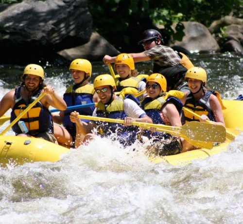
The crystal clear rivers of Bhutan are one of the kingdom’s best kept open secrets. Fed by the glacial-melt of the Eastern Himalayas, six major rivers (Wang Chhu, Sunkosh, Puna Tsang Chhu, Mangde Chhu, Kuri Chhu and Dangme Chhu and their tributaries), have been scouted for kayaking and rafting.
They cut through high valleys and low plains to meet up with the Brahmaputra River in India. The pristine natural setting and the sheer variety of the rivers’ courses provides a unique opportunity to explore Bhutan’s beautiful wilderness. Adventurous travelers will not be disappointed by the rugged, untamed waterways of Bhutan. The rivers are plentiful with strong currents varying between slow, gentle flows in some places and powerful, raging torrents can be found throughout the country. Although adventure sports and tourism are relatively recent introductions to Bhutan, they are rapidly gaining in popularity.
The river courses available in Bhutan offer something for all visitors, regardless of experience: There are easy routes for beginners and hair-raising runs for the veterans. Besides the rafts and the kayaks, Bhutanese agents also organize walking and trekking expeditions along the scenic river banks. The best time for rafting and kayaking is from March to April and November to December.
Safety Notes:
Bhutanese rafting and kayaking guides are well trained and will do everything to ensure that you enjoy the adventure while minimizing the risks. The rivers of Bhutan were first surveyed for potential routes for water sports in 1997 by Gerry Mofatt and Peter Knowles, both experienced rafters/kayakers at the invitation of the Royal Government and the Department of Tourism.
They trained the first batch of Bhutanese river-guides and conducted surveys to grade the rivers. Since then, other rivers have been surveyed including the Punatsang Chhu, Manas and Amo Chhu. TCB guidelines ensure that all operators use well maintained professional equipment and maintain a reasonable guide-client ratio.
The six rivers (wang chhu, Sunkosh, Puna Tsang chhu, Mangde Chhu, Kuri Chhu and Dangme Chhu) have been scouted for kayaking and rafting. The sport offers something of everyone. There is easy rafting for beginners and we also organize walking and trekking expeditions along the scenic river banks.
The best time for rafting and kayaking is from March to April and November to December.
- Paro Chhu (Bondey to Isuna Bridge)
Location: Paro valley, western Bhutan
Length: approximately 10 km (3hours)
Difficulty: class III-IV
Flow: about 500 cts
Seasons: March- April
Craft: kayaks recommended due to narrow and steep rapids.
- Lower Paro Chhu (Isuna Bridge-Chhuzom)
Location: Paro valley, western Bhutan
Length: 7km (1hours)
Difficulty: class II-III with one V
Flow: about 500 cfs
Seasons: March- April
Craft: kayaks (too small for rafts)
- Wang Chhu- Upper Run (Chhuzom Confluence- Lower Tam Chhu, Dobji Dzong)
Location: Thimphu/Paro/Phuntsholing highway, western Bhutan
Length: Approximately 4km (2 hours)
Difficulty: class IV, one V
Flow: 800-1000 cfs
Seasons: March- April, November – December (caution: a high water in this Section is extremely dangerous. Not recommended for amateurs)
Craft: kayaks (too small for rafts)
- Wang Chhu – Lower Run (Tam Chhu- 4 Km Downstream)
Location: Thimphu/Paro/Phuntsholing highway, western Bhutan
Length: 4km (2 hours)
Difficulty: class III
Flow: 800-1000 cfs
Seasons: March- April, November – December (Tips: a high water run is possible with good scouting)
Craft: kayaks, Rafts
- Upper Pho Chhu (Wangthangkha – Samdingkha)
Location: Punakha Valley, Western Bhutan
Length: Approximately 7km (2 hours)
Difficulty: class III-IV
Flow: 2000-3000 cfs
Seasons: March- April, October – November
Craft: kayaks and Rafts
- Lower Pho Chhu ( Samdingkha- Below Punakha Dzong)
Location: Punakha Valley, Western Bhutan
Length: 7km (1.5 hours)
Difficulty: class III with one IV at the bottom
Flow: 2000-3000 cfs
Seasons: March- April, October – November (Tips: runs at high water possible)
Craft: kayaks and Rafts
- Mo Chhu- Tashitang Devil’s Gorge Section (Tashithang- Below Punakha Dzong)
Location: Punakha Valley, Western Bhutan
Length: 12 km, 5-7 hours with Scouting
Difficulty: class V
Flow: 1000 cfs
Seasons: Feb/Dec. (caution: higher than medium flows make this run dangerous. High water runs not recommended for amateurs)
Craft: kayaks and Rafts
- Mo Chhu – upper run (14 km above Punakha Dzong – Kabjisa)
Location: Punakha Valley, Western Bhutan
Length: 3 km (1.5 hours with Scouting)
Difficulty: class IV- V
Flow: 1500-2000 cfs
Seasons: March- April, November- December
Craft: kayaks only.
- Kabjisa- Khamsum Yuling Namgyal Chhorten
Location: Punakha Valley, Western Bhutan
Length: 5 km (1.5 hours)
Difficulty: class III-IV
Flow: 1500-2000 cfs
Seasons: March- April, November-December (Tips: with good Scouting, runs at higher flows Possible)
Craft: kayaks and Rafts
- Lower Mo Chhu ( Khamsum Yuling Namgyal Chorten – Below Punakha Dzong)
Location: Punakha Valley, Western Bhutan
Length: 6 km (1hour) (Note: in spring, High winds and Small currents make this Stretch longer and harder)
Difficulty: class I-II
Flow: 800-1000 cfs
Seasons: March- April, November-December (Tips: with good Scouting, runs at higher flows Possible)
Craft: kayaks and Rafts
- Upper Dang Chhu ( Wangduephodrang Downstream – Kichu Resort)
Location: Wangduephodrang, Western/Central Bhutan
Length: Approximately 3 km (2hours with Scouting)
Difficulty: class IV-V at medium flows, V-V at higher flows
Flow: 400-500 cfs
Seasons: March- April, October-November (Caution: high water makes this run dangerous. Not recommended for amateurs)
Craft: kayaks only (too small and steep for Rafts)
- Middle Dang Chhu ( Kichu Resort- Dang Chhu down –stream)
Location: Wangduephodrang, Western/Central Bhutan
Length: 5 km (1.5 hours)
Difficulty: class IV with three Class V Scouts
Flow: 400-500 cfs
Seasons: March- April, November- December
Craft: kayaks. (Tips: rafts possible but only with crew and portages. It is time consuming but there are great runs at stretches)
- Lower Dang Chhu ( Wangduephodrang upstream- Puna Tsang Chhu Confluence)
Location: Wangduephodrang, Western/Central Bhutan
Length: Approximately 5 km (1hour)
Difficulty: class III+
Flow: Class IV with 3 Class V scouts (Tips: runs possible at high water if the first section is scouted carefully and the paddlers are strong)
Seasons: March- April, November- December
Craft: kayaks and Rafts.
- Puna Tsang Chhu – The canyon ( Kami Chhu- Waklaytar)
Location: Wangduephodrang, Western/Central Bhutan
Length: Approximately 15 km (4hours in Kayaks with scouting, longer for rafts due to portages)
Difficulty: class IV-V at low to medium flows, solid vat-high flows
Flow: 5000-7000 cfs
Seasons: March- April, November- December (Caution: high water on this stretch can be extremely difficult. Not recommended for amateurs)
Craft: kayaks. (Rafting possible with strong crews)
- Puna Tsang Chhu- Waklaytar to Sunkoshtar
Location: Wangduephodrang, Western/Central Bhutan
Length: Approximately 17 km (4hours)
Difficulty: class III- IV at most flows
Flow: 5000-7000 cfs
Seasons: March- April, November- December (Tips: high water makes this run more difficult but reasonable as well)
Craft: kayaks and Rafts.
- Mangde Chhu- Upper Section (Yundo Choling Palace – Langthel)
Location: Trongsa, Central Bhutan
Length: Approximately 5 km (2hours with Scouting)
Difficulty: class IV
Flow: Approximately 3000 cfs
Seasons: March- April, November- December
Craft: kayaks only
- Mangde Chhu- Ema Datsi Canyon (Langthel – Rayfay)
Location: Trongsa, Central Bhutan
Length: Approximately 7 km (3hours with Scouting)
Difficulty: Pool drop Class III- IV at medium flows
Flow: Approximately 3000 cfs
Seasons: March- April, November- December (caution: high water makes this section very dangerous. Not recommended for amateurs)
Craft: kayaks only
- Ema Datsi Canyon _ Kevorkian canyon (Rayfay – Tingtibi)
Location: Trongsa, Central Bhutan
Length: Approximately 50 km (2 river days)
Difficulty: Class V- VI at low to medium Flows
Flow: Approximately 3000 cfs
Seasons: March- April, November- December (caution: high water makes this section very dangerous. Not recommended for amateurs)
Craft: kayaks only
- Chamkar Chhu ( Tangbi – Jakar)
Location: Bumthang, Central Bhutan
Length: 5 km (1hour)
Difficulty: Class II -III
Flow: 1500 cfs
Seasons: March- April, November- December
Craft: kayaks and Rafts
- Tang Chhu ( Misitang – Jakar)
Location: Bumthang, Central Bhutan
Length: 10 km (2hour)
Difficulty: Class III – IV (includes one of the world’s only class VI cases of flat water)
Flow: 300-500 cfs
Seasons: March- April, November- December (caution: high water runs not recommended for amateurs)
Craft: kayaks (Tips: the rapids in the lower section are too narrow to allow a raft to pass. Portaging is not an option)
- Kuri Chhu- Upper Run ( Lhuentse _Tangma Chhu)
Location: Lhuentse, Central –Eastern Bhutan
Length: Approximately 14 km (3hour)
Difficulty: Class IV for the first 7 km, V – VI after that
Flow: 4000-6000 cfs
Seasons: March- April, November- December (caution: high water runs not recommended for amateurs)
Craft: kayaks (Tips: the longer portages and big rapids in the lower canyon make this impossible for rafts.)
- Kuri Chhu – middle run ( Bottom of the upper Canyon – Autsho Village South)
Location: Lhuentse, Central –Eastern Bhutan
Length: Approximately 20 km (3 -4 hours)
Difficulty: Class IV- IV + with a couple class Vs
Flow: 4000-6000 cfs
Seasons: March- April, November- December (caution: high water runs not recommended for amateurs)
Craft: kayaks and rafts.
- Kuri Chhu – lower run (power house- Hydropower project site)
Location: Lhuentse, Central –Eastern Bhutan
Length: Approximately 10 km (1 hour)
Difficulty: Class III
Flow: 4000-6000 cfs
Seasons: March- April, November- December (caution: high water runs not recommended for amateurs)
Craft: kayaks and rafts.


Reviews
There are no reviews yet.